First of all, happy New Years! I hope you’re all looking forward to 2013 as much as I am. Last year was full of awesome life-changing experiences, but I have a feeling that this one is going to be even better.
So after chatting about resolutions with some old friends, I’ve decided that a good new year’s resolution should be more than just another mundane daily goal. Those are great, but you shouldn’t just set them at the beginning of the year and forget about them around February or March, you should adjust and rework them constantly no matter what time of the year it is.
Instead, a good resolution is some extraordinary task or challenge with a deadline of December 31st. Basically, it’s something from your bucket list that you hope to accomplish that year. Because it’s extraordinary, it’s not something that you forget in a month or two. And the deadline gives you a sense of urgency, so you don’t put it off for “someday.”
With that in mind, here’s my 2013 resolution:
Hike four of the seven peaks of Utah County.
I was originally going to go for all seven, but I’m not (yet) an experienced climber, and some of the peaks look a little difficult. Others, though, seem pretty doable. I’ve hiked Y Mountain several times, and got a chance to do a little hiking in Georgia. Four shouldn’t be too much, even with my relatively limited skill level right now.
Of course, I’ll wait until June to make the first hike (probably Provo Peak). In the meantime, I’ll do what I can to get ready: eat healthy, climb a few smaller mountains, and otherwise get in shape for the big ones.
As far as writing goes, I’m going to go back on the early morning writing schedule and shoot for three hours of writing new words per day. My monthly goal is to start / finish / publish at least one thing, and my yearly goal is still to finish at least two novel-length works (2012 was Star Wanderers I-IV and Stars of Blood and Glory).
But it’s hard to call any of those goals resolutions, since most of them are probably going to change over the coming weeks and months. It’s hard to know exactly what life’s going to throw at me once I get back in Utah, so I’m going to stay flexible and just try to do the best I can.
I do want to publish Stars of Blood and Glory next month, and I think I can finish The Sword Keeper before then–if not, then definitely Star Wanderers: Benefactor. After that, I’d like to do a print version of Star Wanderers I-IV with some decent cover art. And Star Wanderers: Dreamweaver will probably be out sometime in the spring.
Beyond that, who knows? It all depends on where the muse takes me. One thing’s for sure, though–I’ll definitely keep writing.
So last week was the first week of school here in Georgia, but before I blog about that, I thought I’d do a post on the short backpacking trip I did with a friend of mine the week before. It was a lot of fun, even if our plans did change about a dozen times along the way. That tends to happen a lot to plans here in Georgia, but if you’re flexible and can roll with it, you can have a lot of fun anyway.
So our original plan was to go from Baghdati to Sairme, a small resort town in the Lesser Caucasus range just south of Kutaisi, and from there catch a bus over the mountain and hike a few trails out in the western side of Borjomi National Park.
Well, when we got to Sairme, we found that there isn’t a bus that goes over that road, and for good reason. It isn’t exactly a “road”–more like an unusually wide dirt path. Farmers sometimes use it, but only because they’re local and it doesn’t make sense to go 80+ kilometers out of the way on the main route from Zestaponi to Surami.
The mountains around Sairme.The “road” from Sairme to Abastumani.
The locals told us it was about 35 km to walk to Abastumani, so we figured “hey, we have food, sleeping bags, and a tent–why not hike it?” According to the map, if we left at 1pm and averaged 3 km/hr, we estimated we should reach the pass just around sunset.
Some interesting moss around the 2,000 meter elevation mark.Mount Didmaghali, just above the treeline. We camped about two kilometers from here.
The calculations were fairly accurate; we hiked for about 6 hours, making about 18 kilometers on the first day and climbing around 1300 meters. In all that time, we only passed three vehicles, and they were all heading back to Sairme. One of them was carrying a bunch of guys who were so surprised to see us, they gave us a giant wheel of cheese. We gave half of it to a local farmer who looked like he needed it more than us, and ate most of the rest over the course of the next few days.
One of the farmers’ huts up above the treeline. The guys who farm here are generally seasonal workers, who live in the valley during the winter.Our campsite, by the side of the road near Mount Didmaghali. It got a little windy at night, but was actually quite comfortable.That moment when you realize “OMG, those aren’t clouds–those are MOUNTAINS!”
We camped out just above the treeline, next to a hill where a bunch of cows were grazing. The local ranchers brought the herd back in while we cooked dinner, which was kind of cool. Imagine a couple hundred cows walking past your tent. The good thing about being so close to the farmers, of course, was that we didn’t have to worry as much about bears and wolves.
At one moment while we were looking out acros the way we came, the clouds on the horizon began to part somewhat, and I had one of those stomach-dropping moments as I realized that most of those white shapes weren’t clouds, but mountains. We were looking at the Greater Caucasus range, with Mount Elrus standing above the mountains of Svanetti and a whole bunch of other snow-capped peaks further off to the east.
As the sun sent, the temperature dropped fairly quickly, and the wind picked up a lot. I wasn’t able to sleep for a few hours, it was so strong. But the stars were beautiful–at one point, I saw a satellite that was so bright it had to be the ISS. Cool stuff!
The farmers bringing out the herd in the morning. One of the cows ate some of our bread, which was kind of annoying, but I guess I shouldn’t have left it out. Cows will eat (or try to eat) just about anything!The view from the top of the first pass, just east of Mount Didmaghali. The little hill on the left is where we spent the night.Mount Elrus, with several other major Caucasus peaks below it. You can also see Kutaisi and some other settlements in the valley.The view from Zedeki pass.
The next day, we had a beautiful hike up to the first pass and over the mountains into Samtskhe-Javakheti. The weather could not have been more perfect–it warmed up as soon as the sun came up, and was pleasant for the rest of the day. We had some amazing views, too, especially from the top of the pass.
The road on the other side of the pass.The view on the other side of the pass. Those are the mountains of Samtskhe-Javakheti, with Turkey and Armenia in the distance.
On the way back, we fell behind a bit, so we decided to hitch a ride with a passing farmer’s truck. The guys were hauling some empty barrels, a bunch of brush, and some calfs, and they put us in the back with the animals.
Wow, was it crazy! The road was so bumpy, literally every other bounce almost threw us off of the truck. The cage would pull back branches and snap them back so hard, some of them could have knocked us off as well, and the cows crapped all over the place, including the back of my pants. For most of the way, we had a sheer cliff on one side, and even though there were lots of trees, it was pretty scary, especially at the switchbacks.
In other words, it was an adventure!
The truck that took us down most of the way. Bumpiest ride of my life!My pants, after the cows got to them.
I wish I had some pictures from the ride, but it was all I could do to hang on for dear life. After about 45 minutes, my hiking partner had had enough, and demanded that the guys stop and let us off. My camera had fallen off in the truck bed, but I didn’t realize that until we were back down. Fortunately, we were only about 5 km from Abastumani, and found the guys just outside the settlement. The camera was still in good shape, and in typical Georgian fashion, they invited us for bread, cheese, and cha-cha.
So it ended up being an awesome two days of hiking and backpacking. The views from above the treeline were incredible, and the conditions were absolutely perfect–we could not have asked for better. We spent the next couple of days exploring Akhaltsikhe, Borjomi, and Bakuriani, but I’ll save that for another post later–this one has gotten long enough.
So yeah, it was definitely worth the trouble bringing out all the backpacking gear from the States. I hope to have plenty of opportunities to use it again before the end of the season!
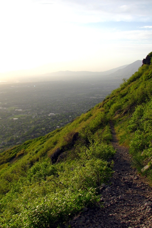
So this last weekend, I decided to solo climb Y Mountain. For those of you who don’t know, Y Mountain is one of the smaller mountains along the Wasatch range local to the Provo/Orem area. It’s called Y Mountain because of the enormous letter “Y” painted on its side (yeah, that’s what they do to mountains in this part of the country).
Of course, the only reason I did a solo hike was because I’ve been up this mountain multiple times before and I know the trail. Plus, it’s kind of a smaller mountain–it’s still over 8,000 feet, but the trail is only about 2 miles long. I’m a slow hiker, so it took me about three hours to get to the top.
To get to the top, you first have to hike the Y, which is the most boring part. The trail is literally wide enough for a truck to drive up–that’s how they repaint the Y every few years–and it’s all on the side facing the valley, so all you can really see is city.
After the Y, you go up a much smaller trail that cuts across the face of the mountain south, into Slide Canyon. At the entrance to the canyon is this really cool rocky outcropping that some people call Lover’s Point–I like to call it the Citadel. The trail winds up the canyon a ways, passes another really cool overlook, and turns a couple of bends before you reach the canyon head.
This is where things get interesting. At the head, there’s a small meadow surrounded on all sides by forest. On the right is a campsite, where the trail forks and heads up to Maple Mountain. If you stay left, though, the trail eventually takes you to the summit of Y Mountain.
The next half mile or so is pretty strenuous. The trail goes through an aspen grove, past another meadow, into this freaky dark forest, past another meadow, into another forest…and then you find yourself in this vast meadow, above the trees, surrounded on all sides by mountains.
I have to be honest: when I got to this point, I was absolutely terrified. The roar of the city was gone (and yes, the city roars–it’s a very distinct sound), the only other people around were a couple of hikers somewhere behind me, whom I hadn’t heard in maybe an hour, and all around was such incredible vastness…it’s hard to explain without actually being there. I just felt so small and isolated, surrounded by this immensity of nature that didn’t know who or what I was, or even that I was…
It was AWESOME.
By the time I got to the peak, the sun had set and the stars were already coming out. I only climbed to the false summit–the one with the view of the entire valley–and from there, I could see past Point of the Mountain all the way north to Sandy, with Spanish Fork and Elk Grove to the south, and Utah Lake a giant puddle in between. It was pretty cool.
But again, the alone-ness of the place really got to me. It made me wonder: is this how future space explorers will feel, when they’re traveling between stars? I can’t imagine how much greater is the vastness of space, compared to what I felt. If so, what kind of an effect with that have on the people who live out there on the fringes of settled space? How will it affect their culture, their religion, their sense of who they are and what their place is in this infinite universe?
I wish I could say I felt this huge sense of triumph after getting to the top, but honestly all I could think was: “oh crap, now I’ve got to walk all the way down.” I did it the same way anyone does anything–one step at a time–and thankfully, I made it down without incident.
Passed a young couple up on a date; they were pretty impressed that I hiked by myself, and gave me some water (which was fortunate–I ran out at the summit). Passed another pair of backpackers who were hoping to camp overnight on the summit, but other than that, I didn’t see anyone else until I got to the Y.
So that was my adventure this weekend, and how I celebrated my 27th birthday. It was totally worth it. In a couple of days, I’ll share the photos.